
Heidi Kaartinen
Ossi Saukko
Marjut Koskela
Åsa Ericson
Johan Wenngren
Johan Lugnet
The Arctic Airborne 3D project, AA3D, is funded by Interreg Nord, Lapin Liitto and Region Norrbotten. It was launched at the beginning of 2019 and ends in July 2022. AA3D develops and uses drone technologies, visualisation, sensor and positioning technologies to demonstrate innovative practical applications.
The project addresses the challenges of Arctic municipalities, tourism companies, reindeer herders and service providers, using the means of digitalisation and the latest drone technologies. This is done to support the mix of entrepreneurs to deploy enabling drone technologies and to create drone-based services. Centria University of Applied Sciences (project owner), Luleå University of Technology (LTU), Finnish Meteorological Institute and Maailmasta Oy are giving their valuable input to the project as partners. By piloting the applications of drone technology, the project intends to support an increase in competitiveness and the development of value adding services.
The requirements and the needs are gathered from the end users’ point of view and pilot cases are demonstrated to meet practical use. The article is a cross-border collaboration between Centria and LTU. The article reports on activities within the tourism area, especially the Finnish 3D map for hiking, and exemplifies how drones can add to the experiences.
Tourism in the Nordic
Ministry of Economic Affairs and Employment of Finland recognises the need of finding the information about the destination before making the actual trip. Destination organisations are valuable sources of information for both planning and decisions. In addition, the social media is recognised as an important source for information (Työ- ja elinkeinoministeriö 2021). Having access to personal, and visual, stories from other visitors is an underestimated channel for ideas for new tourism products. One of the challenges is hence to provide the services that meet the expectations of modern travellers. The so-called silence tourism (“Hiljaisuusmatkailu”, in Finnish) (Valta 2017) and experience tourism attracts more and more people to visit the northernmost parts of Scandinavia. The nature is still intact and the northern lights can be seen in the sky without light disturbances from cities, and the air is fresh to breathe. Tourism entrepreneurs often build on the easy access to the wilderness in their products (Saarinen & Varnajot, 2019). Hence, the natural resources are often turned into businesses.
Last year has been a challenge for the global tourism in northern areas. Borders have been more or less closed all the time to prevent the Covid-19 from spreading. Northern tourism companies have been struggling with operating on fewer international customers willing to pay for experience services, such as snow mobile or husky rides. Many of the companies have turned their business inside out to better respond to the domestic travellers’ needs. The entrepreneurs have noticed the fact that a domestic tourist is the one most likely to return, whereas the international tourists expect to get a once in a lifetime experience (Vaarala 2020). National tourists have discovered the benefits of nature tourism at their home country. This increase has been visible on hiking trails, especially the last year, during the colourful autumn foliage (Ruokangas 2020). It has been estimated, that one third of the tourism within Finland is headed to Lapland (Työ- ja elinkeinoministeriö 2021). New solutions and innovative thinking are needed from the entrepreneurs to continuously attract the tourists to the north.
Many tourist locations have a centralized information point for the region’s touristic offerings, with detailed information in printed brochures and information boards about the types of services and options available. Tourists can be encouraged to take advantage of the services, especially if they are offered a more visual and interesting way, to plan and explore destinations in advance, add value during the stay, and relive the stay when they are at home. Digital solutions provide such pre-, on-site and post-visit opportunities (Rahman et al., 2014). Thereby, for example, the degree of difficulty of a hiking route can be assessed in advanced, and the route can be planned to fit the whole family in respect of cultural places to visit, and where to rest for lunch. There are many ways that digitalization adds extra value to tourism and provides an opportunity to meet the expectations of modern tourists. This article will exemplify a number of such possibilities.
Hiking tourism: an application for a 3D experience

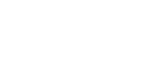
AA3D has created a virtual solution to add value to the hiking tourism in Kuusamo, northern Finland. The application provides information about two hiking trails of the area in many aspects. A simple user interface views a 3D map of the area (Fig. 1), where the points of interest (POI) can be easily viewed. The demonstration application can be viewed and used on a touch screen at the tourism centre Karhuntassu.
Two hiking destinations of Kuusamo area are presented in the demonstration application: Pieni Karhunkierros trail and Salpalinja trail. There are marked info points on the 3D map, which can be activated for additional info about the destination by a tap on the screen. The user view focuses to the spot and the additional POI’s become visible. The application includes the following features (POI’s): virtual hike (video), which also includes the information about the steepness of the hiking trail, pictures and videos from the destination and drone content from the area.
The application provides variety of different information about the hiking trails. The virtual hike can be rewound to the desired spot and the application visualises the spot on the map (Fig. 2). The altitude profile and current altitude can also be viewed on the bottom of the application window. The experience is completed with audio and local music recordings.

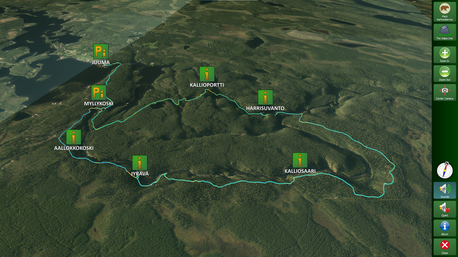
The Map Maker tool, which is the base for the visualization, uses the National Land Survey of Finland’s open datasets. It is also possible to use other sources, but so far, the application has been made to work in Finland and with material from National Land Survey of Finland’s database. For Kuusamo, a height model was combined with the surface from the aerial photographs to create a three-dimensional model of the terrain (Fig. 3).
The tool gets information about the outlines of buildings and the number of floors from the Land Survey’s terrain database. With the help of this data, the tool adds models of buildings to the terrain map. The Map Maker suffices to add the necessary datasets and specify the areas from which 3D maps are desired. In the next version the heights of buildings are taken from point clouds, which are also available at the National Land Survey of Finland’s database.
There has been a high interest in a mobile version of the hiking application. Creating a mobile app is a natural continuation for the desktop application, thereby providing a solution on the go which must be the optimal solution to support better experiences during the hike.
Where are AA3D going next?
There are lots of possibilities to adapt the technologies to the unique needs of tourism. For example, the actual weather information could easily be displayed in the application before starting the hike, along with forecast for the day. Also, sending timely warnings if the weather changes rapidly as it usually does on hike in the mountains, would be possible.
Tests with drones in wilderness tourism have been initialized. The LTU team is measuring and evaluating the sound level of different types of commercial drones to assess how, for example, dogs, elks and bears, react (or not) when the drone is used to provide close experiences for tourists – of course sitting securely in their hiding place. In relation to this, follow-me functions will be tested in hiking tourism to assess how much the sound will disturb the silence. Drones enhance the experience by adding a bird’s view, for example following you wherever you are on the trail. Using the drones for delivering things to people is another issue under consideration in AA3D. Drones can also be used to add value to the emerging trends of slow-tv based on nature tourism (Östemark 2021), and also on other interesting slow-tv events that takes place, e.g., a sea transport of a huge bridge (https://www.svtplay.se/guldbron).
Beyond Visual Line of Sight flying (BVLOS) is also an interest for the future. Imagine to climb a mountain, but from distance. Such tourism products would provide access for an audience beyond those who actually can visit the place in real life. For this to come true, there is a requirement for drone driver’s licences for out-of-sight drone operations, and new types of guides are also needed, i.e., drone guides. Thus, drones may also create new jobs.
The LTU team collaborates with tourism entrepreneurs and eco forests to turn text-based signs into better, visual and interactive, signs. The solution is both physical since the solution is a transparent board with etched details that gives a better picture of a historic site and its buildings, and digital using QR-code for storytelling.
Best season for hiking and drone operations is from spring to autumn and project partners are busy preparing the upcoming demonstrations for entrepreneurs and stakeholders related to virtual tourism and drones. Changes in drone regulation are affecting all partners work and new regulation needs to be adopted, as well as the information about the changes needs to be shared, so that the drone operators from amateurs to professionals have a better knowledge about the safe drone operations.
References:
Rahman, N.A.W.A., Kim, S., and Brown, S. 2014. “Constructing and Shaping Tourist Experiences Via Travel Blog Engagement. Tourists’ Perceptions and Assessments”. Advances in Culture, Tourism and Hospitality Research, Vol. 8: 129-135.
Ruokangas, P. 2020. ”Tilastot sen todistavat: Suomalaiset tekivät viime vuotta innokkaammin ruskaretkiä Lappiin”. Online news, 28.10.2020. Available: https://yle.fi/uutiset/3-11617227. Viewed: 26.1.2021.
Saarinen, J., and Varnajot, A. 2019. ”The Arctic tourism: complementing and contesting perspectives on tourism in the Arctic”. Polar Geography, 42(2): 109-124.
Työ- ja elinkeinoministeriö 2021. ”Kotimaanmatkailun nykytila ja potentiaali –selvitys kohderyhmistä ja kehittämistoimista”. Online document. Työ- ja elinkeinoministeriön julkaisuja 2021:14. Available: https://julkaisut.valtioneuvosto.fi/bitstream/handle/10024/162882/TEM_2021_14.pdf?sequence=1&isAllowed=y Viewed: 29.3.2021.
Vaarala, V. 2020. ”Yllätys Lapin matkailussa: ”Kausi oli koronasta huolimatta yksi parhaista”, sanoo 32-vuotias nuori yrittäjä – tutustuimme uusiin oivalluksiin”. Online news, 26.12.2020. Available: https://yle.fi/uutiset/3-11680136. Viewed: 26.1.2021.
Valta, L. 2017. ”Hiljaisuus on nyt kuumin matkailutrendi – matkailuyrityksille se tarjoaa uusia mahdollisuuksia”. Online news, 9.3.2017. Available: https://yle.fi/uutiset/3-9424862 Viewed: 29.3.2021.
Östemark, M. 2021. “Startdatum för årets stora älgvandring är beslutat”. Online news, 1.3.2021. Available: https://www.svt.se/nyheter/lokalt/vasternorrland/startdatum-for-arets-stora-algvandring-ar-beslutat Viewed: 15.3.2021.
Heidi Kaartinen
RDI specialist, project communications
Centria University of Applied Sciences
Tel. +358 40 729 9951
Ossi Saukko
RDI specialist, software development
Centria University of Applied Sciences
Tel. +358 44 449 2658
Marjut Koskela
Project manager
Centria University of Applied Sciences
Tel. +358 40 729 9937
Åsa Ericson
Professor, information systems
Luleå University of Technology
Tel +46 920 492 061
Johan Wenngren
Researcher, information systems
Luleå University of Technology
Tel. +46 920 492 059
Johan Lugnet
Researcher, information systems
Luleå University of Technology
Tel. +46 920 491 201